
Boundary Issues, Day 5: Follow-Up Roundup!
It’s the fifth and final installment of our weeklong look at territorial borders.

This post is part of a weeklong series of articles about territorial borders, called Boundary Issues. You can see other articles in this series, along with the article from last week that inspired this week’s content, here. All articles this week are non-paywalled. Enjoy!
When I decided to do this weeklong Boundary Issues series, I had already mapped out what I planned to publish on the first four days. I left Friday open, because I figured the the first four installments would generate lots of ideas and feedback that I’d want to address on the fifth day.
And that’s exactly what happened. So this final installment of Boundary Issues will be a grab bag of border-related information that came my way in response to this week’s content. I’ll address them one at time, starting with…
The Coolest Border Monuments Ever!
On Wednesday I wrote about Canusa Road, which runs along the border between Beebe Plain, Vermont, and Stanstead, Quebec. As I wrote at the time:
According to Wikipedia, “The yellow line running down the middle of the road in the section along the 45th parallel is treated as the international border, separating United States on the south from Canada on the north.” But … the road actually has a double yellow line, so wouldn’t the border actually be the blank space in between? Or, more specifically, the midpoint of the blank space?
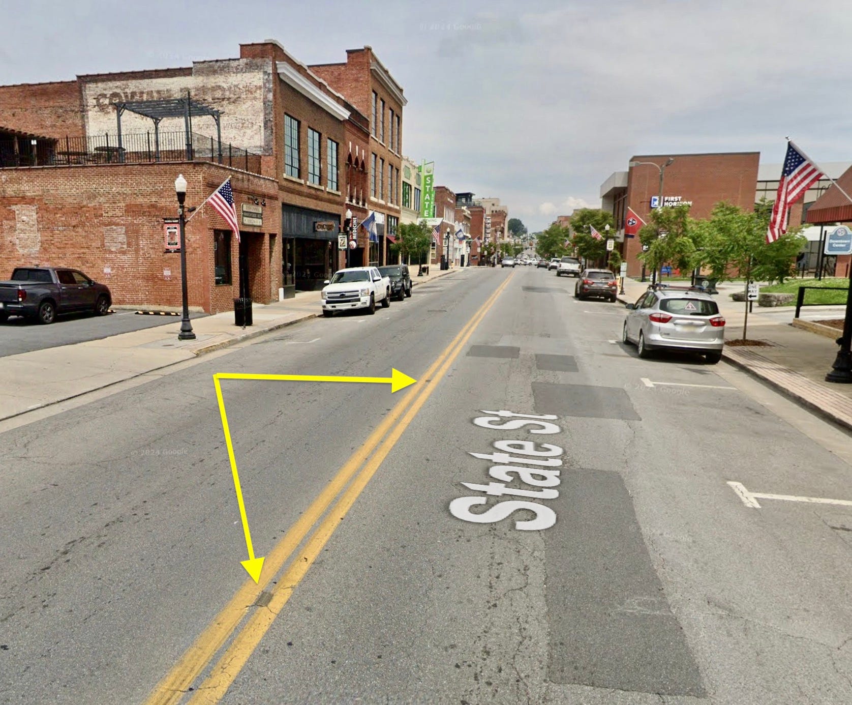
The neighboring cross-border towns of Bristol, Tennessee and Bristol, Virginia have found a novel way to address this very question. First, here’s a look at where the two Bristols are located:

The two Bristols form one community. If we zoom in, you can see that the main drag is called State Street, and it runs right along the border (perhaps it should really be called States street, plural):

Just like Canusa Road, State Street has a double yellow line. It also appears to have those little reflector thingies embedded in between the two yellow lines, as you can see here:
But it turns out that those embedded thingies are not reflectors. Let’s zoom in even more to see what they are:
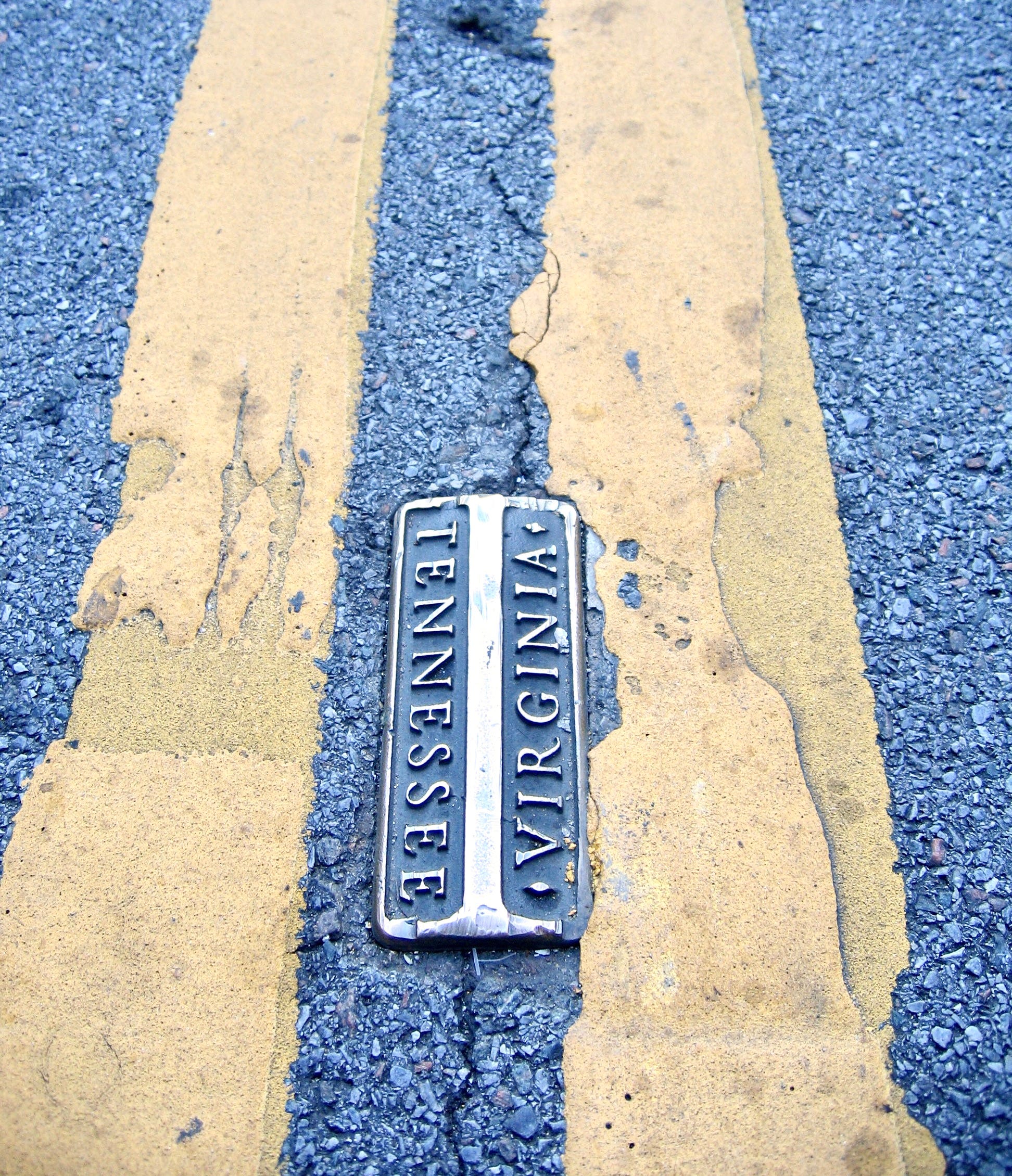
Oh, man — when I saw that photo, I literally said out loud, “That is outstanding!” These little metal markers are embedded in a four-black stretch of State Street. The local tourism website says they were installed “decades ago” (annoyingly vague) and doesn’t say how many of them there are (also annoying), but whatever — I’m prepared to call them the coolest border monuments in America. I wish I’d known about them earlier, so I could have included them in Tuesday’s article about boundary markers.
You can get a better sense of what these markers look like, including their underside, by looking at this one, which apparently sold on Etsy for $795!
(Lots of readers mentioned Bristol to me this week, but reader/commenter Alex Weston is the only who mentioned the pavement markers. Big thanks to him!)
A Bizarre Border-Related Criminal Case
By treaty, the U.S./Canada border from Washington to Minnesota is the 49th parallel. But due to some surveying errors in the 1800s (a common border bugaboo), some parts of the border were inaccurately marked slightly south of the parallel, and others slightly north of it. One of the latter errors occurred in what is now the town of Sumas, Washington, which includes a strip of land, known as the Canada Strip, that is above the 49th parallel and thus should have been part of Canada, but is below the mis-surveyed-yet-official border and is thus part of Sumas.

The International Boundary Commission has ruled that the official border will reflect the long-ago surveys, even if they were erroneous. But the Washington State constitution stipulates that state’s northern border is the 49th parallel — even though that isn’t true in some places, such as Sumas. That led to a novel legal argument by the defendants in an early-2000s criminal case about an infraction that took place in the Canada Strip. Reader Mike Styczen explains:
Some idiots were caught with drugs in the U.S. in the Canada Strip and charged with state drug crimes. Their defense: They were in the U.S. (because they were south of the official mis-surveyed border) but not yet in Washington State (because they were above the 49th parallel, which the state constitution defines as the state line). According to this argument, a little tiny sliver of the U.S. is technically not part of any state, so Washington state law shouldn’t apply.
The state supreme court rejected this argument, basically saying that the Washington State constitution had a clerical error in it. But the dissent (search for “Sanders” in the decision) is absolute fire about the majority’s soft approach to what the dissenting justice considered clear language in the state constitution.
There’s a good article about all of this here.
District of Columbia Boundary Monuments
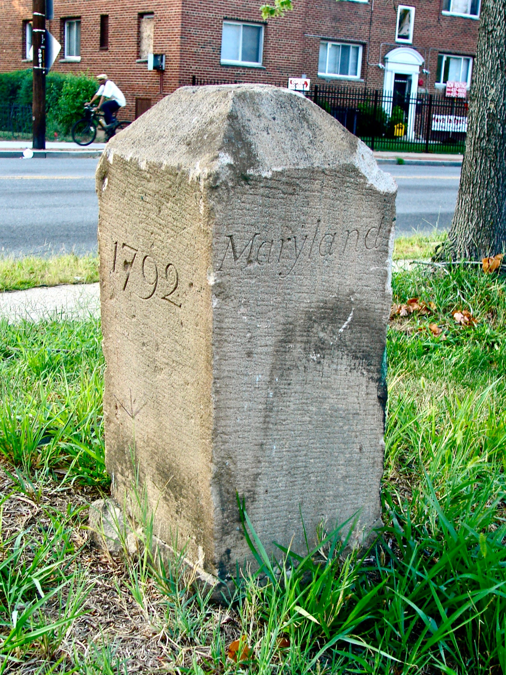
Within minutes of my posting Tuesday’s article about border monuments, I heard from several readers expressing surprise that the article didn’t mention the stone markers outlining the District of Columbia’s border. These were installed in 1791 and ’92, making them some of the nation’s oldest border monuments. Here’s a 1905 chart showing their locations:
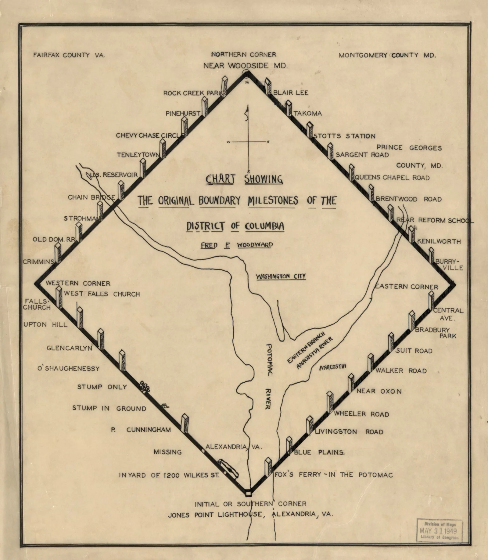
In 1915, the Daughters of the American Revolution began putting protective fencing around the markers. Here’s an example of that:

I definitely would have included these monuments in Tuesday’s article if I had known about them. If you want to learn more about them, here’s a historical backgrounder, a good article, and a fun video.
(Big thanks to readers Michael Romero, David Raglin, and James Gilbert for schooling me on this topic.)
Which Border Monument Is Correct?
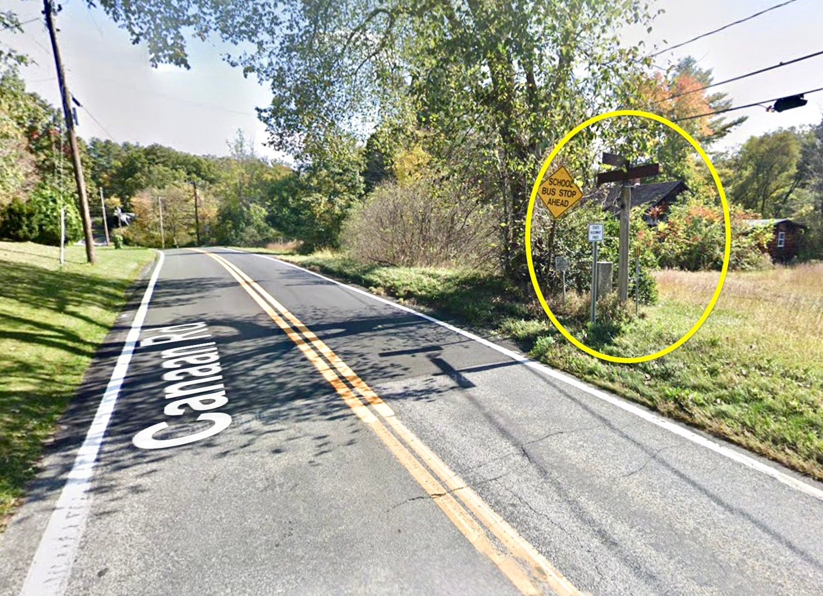
The image above shows a Connecticut highway called Canaan Road as it cross the border into Massachusetts. As you can see in the area I’ve circled, there are two border monuments on the side of the road. Here they are from a different angle:

So there’s a short one, which is a traditional-looking stone marker, and a taller one with rusty signs. Here’s a closer look at the short one:
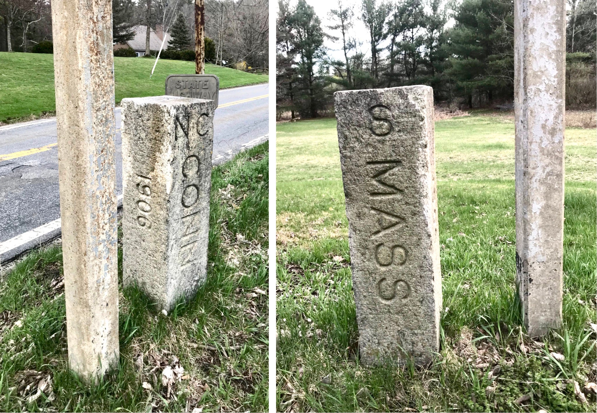
Reader Marcus Tonti, who took those photos, says the “NC” is the first shot is for New Canaan, Connecticut, and the “S” in the second shot is for Sheffield, Massachusetts.
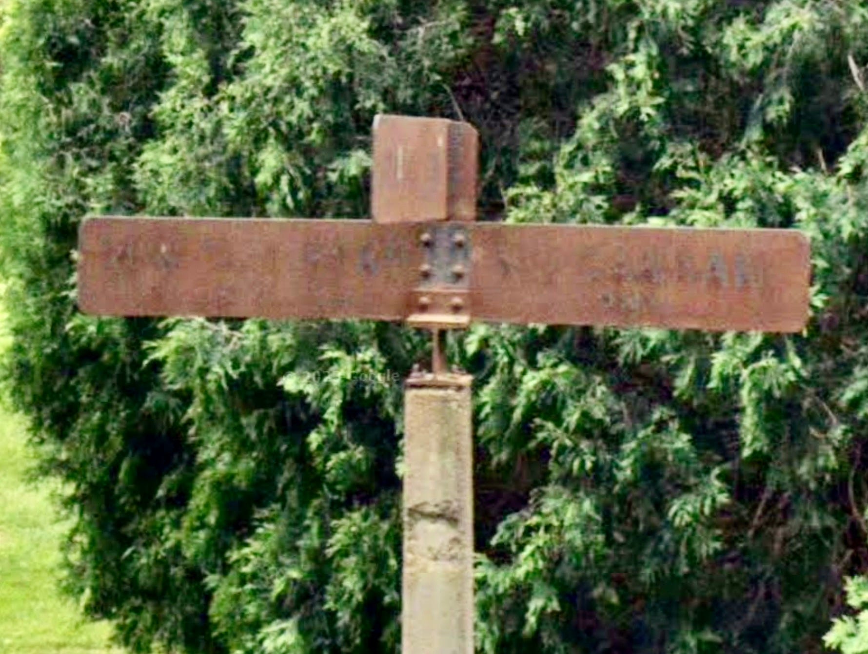
Unfortunately, Marcus didn’t take photos of the rusty signs on the tall marker, but Canaan Road zigzags back and forth across the border several times, so I used Google Street View to find similar signs at other border crossings. Here’s one where the sign extending to the right appears to end in “AN,” suggesting that it probably said, “New Canaan”:
But here’s the thing: I found some border spots with the tall, rusty monuments, and others with the short monuments, but the first photo of this section was the only spot I found with a short and tall marker — and they’re several inches apart! They can’t both be correct, right? Obviously, a few inches of variance on a country road doesn’t really mean much, but it underscores how borders are inherently inexact, despite all the devices we use to make them seem precise.
And speaking of Connecticut, let’s talk about…
Interstate 684 in Greenwich, Connecticut

See how the yellow arrow is pointing at that little stub at the southwestern corner of Connecticut? The far end of that stub is the town of Greenwich, a small portion of which has become sort of a de facto exclave. Let’s zoom in on Greenwich for a closer look:

As you can see, I-684 cuts through Greenwich’s northwestern corner. But there are no exits during the highway’s 1.4-mile path through Connecticut, nor is there any way to cross the highway. So anyone in that little corner of Greenwich is basically cut off from the rest of the town — and the state. Although, to be fair, there isn’t much going on there, as you can see if we zoom in even closer:

Note that there’s a business called Enclave on the New York side of the border! It’s a real estate development. Now they just need a corresponding development on the other side of the border called Exclave.
According to Wikipedia, I-684 continues using New York State reference markers during its short journey through Connecticut. There’s also this:
The short section of I-684 in Connecticut is owned by the Connecticut Department of Transportation, but maintenance and repairs to the stretch are performed by the New York State Department of Transportation, with the cost of maintenance being reimbursed to New York by Connecticut.
Fascinating!
(Big thanks to reader Anthony Verna for contributing this one.)
Glenwood Street in Queens and Nassau County, New York

The New York City borough of Queens (shown above) shares a border with Nassau County on Long Island. If we zoom in on the area marked by the orange arrow at top right, you can see that there’s a Queens street called Glenwood Street that just barely crosses over into Nassau (the dotted red line is the border):

Now, if you know anything about Queens, you know that the buildings tend to have four- and five-digit street addresses, often with a hyphen, like 123-40 83rd Avenue, or 60-80 70th Road. But the four houses on that little strip of Glenwood Street are technically in the Long Island town of Great Neck, so they’re numbered 1, 3, 5, and 7. Here’s one of them:
The photo above shows 5 Glenwood Street, which is Great Neck. The house directly across the street from it is in Queens, so it is 4314 Glenwood Street. Crazy!
I learned about this one from Kevin Walsh, who runs the awesome site Forgotten New York. He’s documented a similarly obscure situation involving another part of the Queens/Nassau border, which you should definitely check out on his site.
Mike Raymer’s Epic 10-State Run

Reader Mike Raymer raised money for his nonprofit last year by swimming in all five of the Great Lakes in one day. This year he and a colleague plan to run one mile in 10 different states in one day, as shown above. “When it’s all said and done, we will have crossed nine state borders,” he says. “The big wild card will be traffic, especially when we’re making our way to the Brooklyn Bridge for the New York mile of the run. We picked a Sunday, hoping that traffic would be slightly better than on a typical weekday.”
And there’s more…
There’s a whole website devoted to European enclaves and exclaves. (From Frank Boscoe)
Wikipedia has a page with an extensive list of U.S. border irregularities, and another one that lists border disputes between U.S. states.
Anyone interested in state borders should probably have a copy of the book How the States Got Their Shapes (highly recommended). I’ve also heard good things about its spin-off TV show from the History Channel, although I haven’t seen it myself.
Another potentially interesting book: Atlas of Unusual Borders: Discover Intriguing Boundaries, Territories and Geographical Curiosities. I haven’t read that one, but reader Kevin Zdancewicz recommends it.
And here’s a good website devoted to “unusual places that can be found on maps that just don’t seem to make sense.” (From Patrick Sharon)
Here’s a fantastic look at points of interest along the U.S./Canada border. (From Bo Baize)
Here’s a video shot by two guys who camped overnight right under one of the U.S./Canada boundary monuments in the Slash. (From Jeremy Poursine)
The town of Phillipsburg, New Jersey, is located right against the N.J./Pennsylvania state line. So what are their local high school teams called? The Stateliners, of course! Unfortunately, their teams don’t have border-themed uniforms or logos, although the words “Stateliners” and “Liners” both figure prominently. (From Mike Wilson)

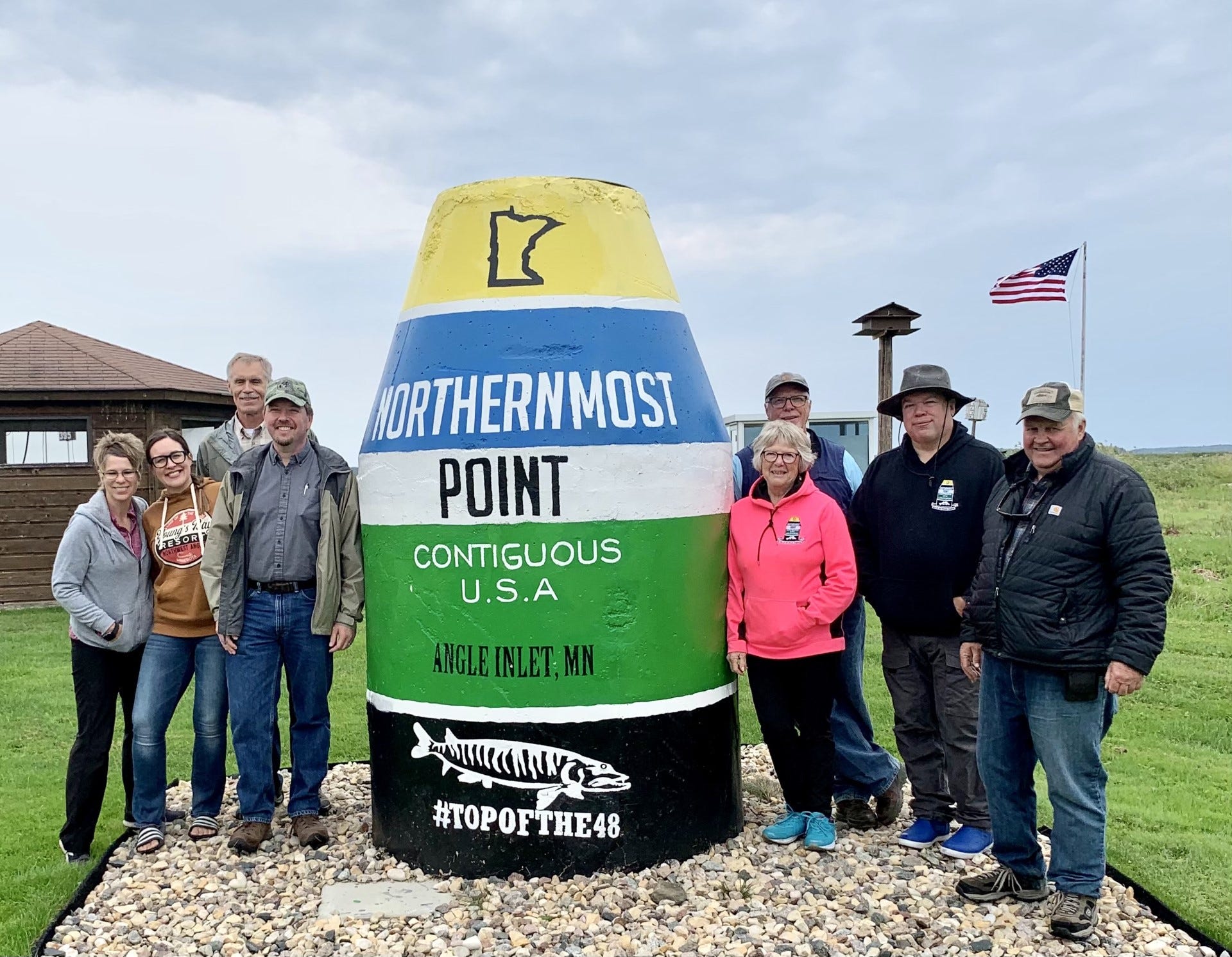
You probably know about (and maybe have even visited, as I have) the oversized buoy monument in Key West, Florida, marking the southernmost point in the continental United States. But you might not know — or at least I didn’t know — that there’s a copycat buoy in Minnesota’s Northwest Angle, marking the northernmost point. Obviously, they can’t say it’s the most northerly spot in the continental U.S., because that honor belongs to Point Barrow, Alaska, so the Minnesota buoy instead claims to be the northernmost spot “in the contiguous U.S.A.” But as we’ve covered previously, the Northwest Angle is a pene-exclave, so I question the use of “contiguous.” Perhaps “in the lower 48 states” would be a better descriptor. (With thanks to Jordan Cutler)
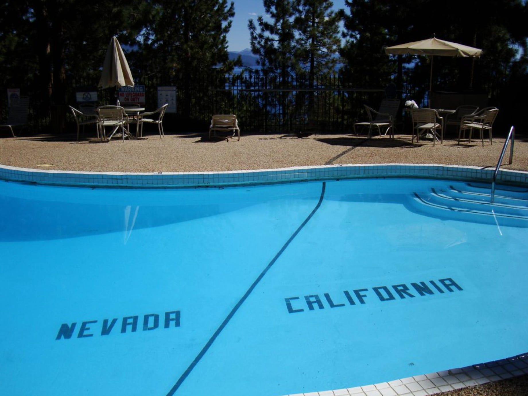
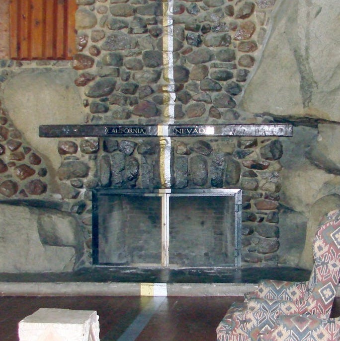
Reader Aaron Wiens writes: “I remember as a kid swimming laps between California and Nevada at the now-defunct Cal Neva Resort near Lake Tahoe. The state line ran down the middle of the swimming pool, and the fireplace inside was split in two with a gold line for California and a silver line for Nevada.”
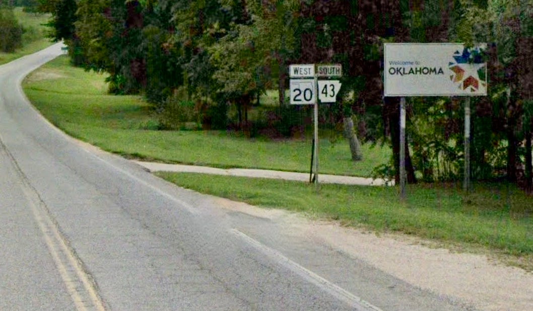
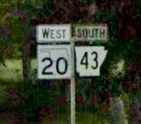
We’ve looked at lots of roads that run along borders, but Austin Gillis has pointed out a particularly odd example of that: As Arkansas Highway 43 crosses into Oklahoma, it runs along the border between the two states and is also Oklahoma Highway 20. That leads to this unusual signage situation:
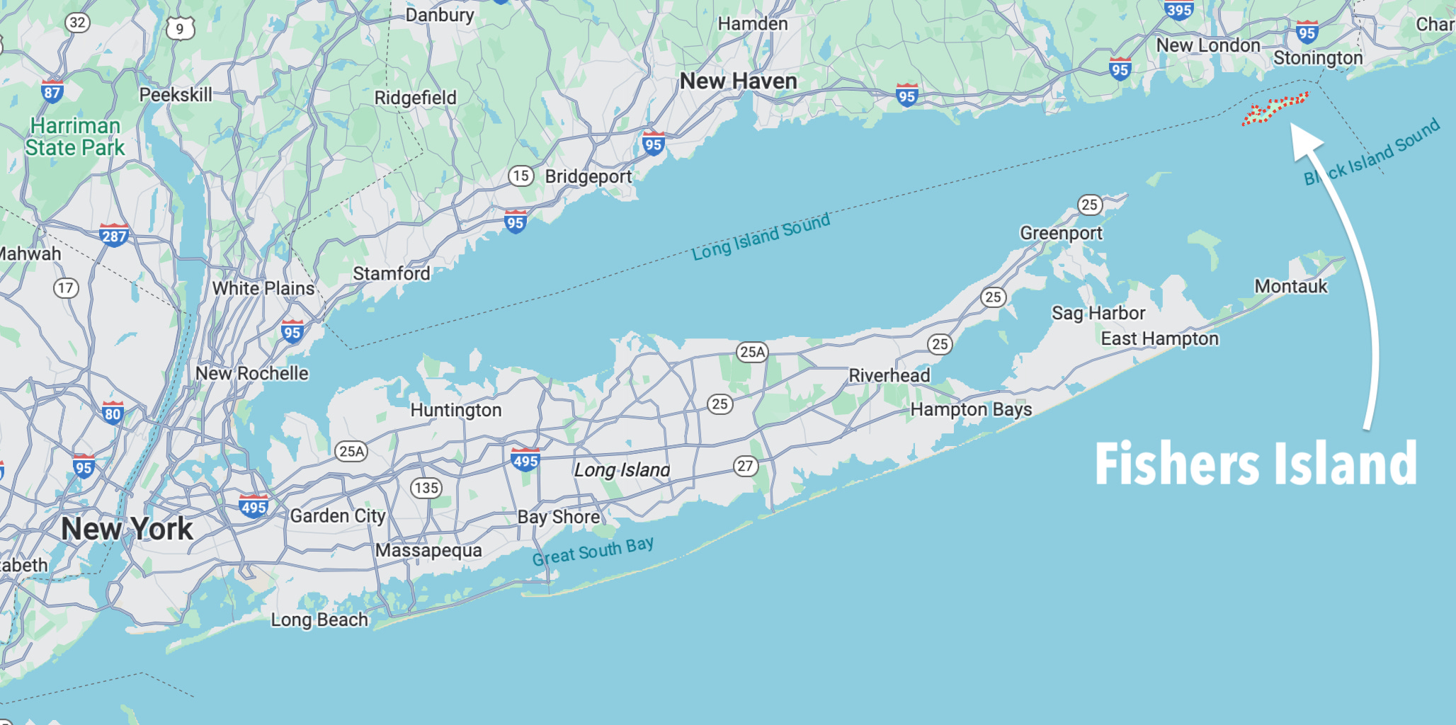
The island town of Fishers Island, New York is located off the eastern tip of Long Island. It’s much closer to Connecticut than to New York, so its mail is delivered by boat from the Connecticut mainland. As a result, it has a Connecticut-style ZIP code — 06390 — making it the only New York municipality whose ZIP code doesn’t begin with “1.” (Its area code, however, is 631, just like the rest of eastern Long Island.)
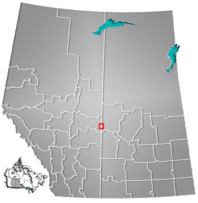
The Canadian city Lloydminster not only straddles the Alberta/Saskatchewan border but is actually incorporated by both provinces as a single city with a single municipal administration. Additional info here, and here are two maps showing Lloydminster’s location (with thanks to reader Gary Moore):

A few hours after I added that Lloydminster item to this list, The New York Times ran an article about how selling food in Lloydminster can be tricky due to trans-provincial border regulations.
The Netherlands village of Baarle is on the border with Belgium and has a bizarre geography that includes 22 enclaves belonging to Belgium, seven of which in turn feature Dutch enclaves. “Often these boundaries run through houses,” says reader Perry van der Meer. Additional info here and here, and here’s a map of Baarle:

Phew — that’s a lot of borderology! Obviously, there are still lots of border-related topics I didn’t get to, including the Southwick Jog; Delaware’s 12-Mile Circle and Delaware Wedge; the border-straddling Carowinds amusement park on the North/South Carolina state line; the town of Carter Lake, Iowa, which is the only part of Iowa that’s west of the Missouri River, because an 1877 flood redirected the river’s course; Indiana’s unusual time zone borders; and a lot more.
And that, my friends, brings our weeklong Boundary Issues series to a close. I’ve had a blast geeking out over these cartographic curiosities, and I hope you have as well. I can’t keep up this daily pace on a regular basis, but doing it for this week has been really enjoyable.
On a personal note: I was hoping that a weeklong non-paywalled series might encourage a bunch of our free subscribers to sign up for a paid subscription. Unfortunately, that hasn’t happened — at least not yet. If you’re a free subscriber and you’ve enjoyed Boundary Issues, I respectfully ask that you please consider upgrading to paid. I feel like the content and community we have here is pretty special, and I’d very much appreciate your support.
If you’re already a paid subscriber, (a) thank you!, and (b) remember that you can always give a gift subscription to that special someone who has the right sensibility for IC. Also, if you want to fund a subscription for me to raffle off, get in touch and we can set that up.
Okay, end of sales pitch. We’ll go back to non-border topics, and a less frantic publishing schedule, next week. Take care.
Paul Lukas has been obsessing over the inconspicuous for most of his life, and has been writing about those obsessions for more than 30 years. You can contact him here.
Great series Paul and thanks for helping others become more borderly aware! Living no more than 3 miles either side of the Ohio/Michigan border my entire life it’s amazing how you can take the border for granted because it’s part of your daily life as I’ve routinely crossed it for school, work or other daily life activities since reaching adulthood. I think a person’s awareness of border issues is inversely proportional to the distance from which they reside to the nearest border. That never became more clear to me than while living in Michigan our son was being denied state scholarship funding to attend the U of Michigan. Legislation had been proposed to limit the funding to graduates of in-state high schools, but our son graduated from the closest parochial school to us which was also my HS alma mater in Toledo. I ended up testifying in front of the Michigan state senate education committee to get the legislation changed. During questioning, one senator from the middle of the state asked me somewhat rhetorically why anyone would go to an out of state high school. My response was to beg forgiveness for not living farther away from the border and causing the issue. Fortunately another senator had a son at an out of state academy and saw to it that the border issue went away.
Lloydminster. Former Washington Capitals goalie Braden Holtby is from there! He thinks of himself as from Saskatchewan, but his house as an adult is in Alberta with a view of Saskatchewan from his backyard. He had both provincial flags on the backplate of his mask. (The blue flag is AB; green and yellow, SK)
Link https://russianmachineneverbreaks.com/2010/09/11/braden-holtby-debuts-his-new-goalie-mask-on-caps365/